
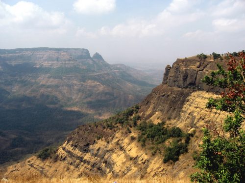
Dramatic landscapes invite wonder. The sheer stark rock of Devil’s Tower, the vast emptiness of the Utah salt flats, and the deep plunge of the Grand Canyon all seem to be beyond our limited human imaginations. One such landscape can be found in Southeastern India, in a region known as the Deccan traps. The Deccan traps are one of the world’s largest volcanic plateaus, stretching across over half a million square kilometers and covering an area larger than Washington and Oregon combined. Sixty-five million years ago, this region became very geologically active. Volcanic eruptions shook the Earth, adding layer after layer to the Earth and stretching several kilometers into the sky. Some scientists have even suggested that these eruptions were a major contributing factor to the Cretacious-Tertiary extinction event, which wiped out the dinosaurs.
Such an impressive geological feature must have had an equally impressive geological cause, but unlike the easy-to-
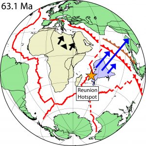
see traps, these causes are buried deep—deep below the surface, and deep in the past. The Deccan traps were certainly created by a hotspot, or a large upwelling of hot magma in the mantle. The previously-accepted theory says that the Deccan traps were caused by the Reunion hotspot, located a thousand miles to the east of Madagascar. As the subcontinent of India moved from near Antarctica up into the Eurasian continent, it passed over this hotspot and formed these Deccan traps. But now, Professor Petar Gilsovic and Professor Alessandro Forte from the University of Quebec at Montreal have created more accurate models, predicting that a second hotspot also fed into these volcanic eruptions. In the journal Science, they published a new back-and-forth time integration method to create a more accurate model of the whole Earth, possibly unlocking a better understanding of our Earth’s dynamic past.
The Earth is an incredibly complex and dynamic object, as rocks swirl and churn deep below our feet. Understanding the Earth’s interior today takes complex instrumentation and research, but looking backward in time is even harder. The physical laws that govern how the Earth changes are as chaotic and nonlinear as the butterfly effect, where a flap of a butterfly’s wings in the Amazon could cause a hurricane off the coast of France. “The Earth is profoundly nonlinear,” says Professor Forte, one of the coauthors of this report. That nonlinearity causes errors to cascade and multiply, especially when viewed over the span of millions of years.
Even basic physics seems to stack the deck against the prediction of the Earth’s past. One basic physical force that shapes the Earth is thermal diffusion, the distribution of heat throughout the Earth, whether in magma pockets in the mantle or in cooling vents near the crust. However, thermal diffusion is often a one-way process, always moving forward in time. A simple example can be found in your morning habit of a cup of coffee with cream. As you stir in cream into the coffee, the cream quickly dissipates throughout the coffee. It would be nearly impossible to trace back the exact location where you began pouring the cream, given only the final state of the coffee.
Despite these challenges, many geophysicists have still tried synthesizing all the data they can collect on the past to create a model for a past Earth. Then, to see if their guesses hit the mark, they apply known physical laws like thermal diffusion and fluid dynamics to time-evolve the modeled Earth to its present state. If their model matches our current Earth, then the initial prediction was somewhat accurate. But because of the nonlinearity of these physical laws, it becomes incredibly difficult to make accurate predictions past roughly thirty million years ago.
The new research takes a different approach. Instead of synthesizing data from the past, they use the most up-to-date data of the present Earth to make predictions for the past. They apply physical laws to time-evolve forward to the present day and check to see if any errors showed up. An algorithm then seeks the smallest possible change that can reduce these errors, creating a slightly modified model. With this new model, just rinse and repeat. As the model tangos through time, it sweeps back and forth, and back and forth, checking for errors and making tiny corrections. Eventually, one of the predictions exactly matches our present Earth.
To even begin this process, an in-depth understanding of our Earth is required. Although we can’t just look through the ground and see everything, there are very clever instruments that map the Earth. Adventurers of the past may have hiked up mountains to measure their altitudes, but today scientists can also use GPS and other satellite technologies to determine the Earth’s topography. To image the inside of the Earth, seismologists use earthquakes as light sources and measure how they bounce and reflect. Like x-rays revealing our bones and tissues, earthquakes reveal detailed structures within the core and mantle. Further data, for example measuring how the Earth distorts gravity, enables even more precision in measuring.
Armed with a detailed understanding of today’s Earth, it is still difficult to understand why this method works. Is this not just a case of a student with an answer key, trying to guess the correct steps without understanding the question? The fundamental difference is that under this method, physical laws are being applied and evaluated. One place where this can be best seen is with the velocity of tectonic plates. As the churning of the mantle below the crust moves tectonic plates on the surface, the plates gain different velocities. However, the relationship between mantle and crust is very complex, depending on viscosity and thermodynamics.
Many other models simply use known data, gathered from other sources, to assign velocities to each of the plates. “We referred to this procedure flippantly as ‘The Hand of God,’ because there wasn’t anything predicted based on what was going on inside the Earth,” said Forte. Using a more advanced physical model, Forte removed the Hand of God from these models to better understand how the Earth really was. Professor Jun Korenaga from Yale’s department of Geology and Geophysics, another expert on mantle dynamics, has reservations on models predicting further than 100 million years ago, especially because of the complexities of viscosity. “Nobody really knows how to simulate plate tectonics,” said Korenaga. But even with these shortcomings, Forte and Gilsovic were able to find very interesting results.
The researchers applied this technique to the Deccan traps to understand their origin. Although the Reunion hotspot has long been thought to have been the only driving force of this catastrophic force of nature, Forte and Gilsovic discovered a smaller hotspot that also fed the volcanos. The Comoros hotspot is a several hundred kilometers northeast of the Reunion hotspot, but the models of the Earth show that they also contributed greatly to the Deccan traps 65 million years ago. Although these regions appear separate today, they were once joined below the surface, giving rise to a fearsome display of fire and lava. “We think of eruptions [like Mount Saint Helens] as being fantastic volcanic eruptions today, but they are literally a pinprick when compared to the amount of lava erupted in forming these Deccan traps,” said Forte.
Hopefully, the Deccan traps mark only the start of the story. The researchers plan to continue using this method to make further predictions on other interesting geological features, including the creation of the North Atlantic Ocean 55 million years ago. If further developed, this could be another tool to understand the awe-inspiring and wonderful forces that shaped the place we know as our home.