
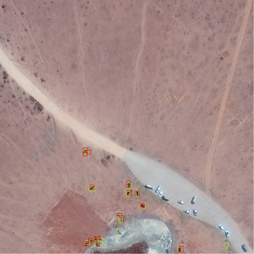
Protection of the world’s animals presents many challenges, but conservation’s newest defense weapon actually works from space. One of the problems conservationists and zoologists face is tracking the location and movements of the animals they are studying. Isla Duporge, a Zoology Ph.D. candidate at Oxford University, and Olga Isupova, assistant professor of Artificial Intelligence at the University of Bath, led a team that found a niche in the field of satellite imagery technology, using their creativity to assist the conservation fight for African elephants. Duporge focuses on Addo Elephant National Park in South Africa, an elephant reserve. There, the large population of elephants allows for a more controlled environment in which to test elephant detection software. Though the technology for studying large animals in a homogeneous environment has existed for quite some time, the novelty in Isla’s approach lies in the application of machine learning.
The Isupova lab’s neural network (NN) was applied by passing a satellite’s gaze over a particular area, such that the contrast between the animals and the surrounding landscape could be used to count animal populations. A NN is a type of machine learning where the makers of the study use a computer algorithm that takes in mass amounts of data—in this case, images of the savannah. First, the satellite takes in images of the savannah as input. Within these images, the study makers identify the elephants. This is the training phase; after a while, the NN sees what study makers have previously identified as elephants, and “learns” that a grey blur is actually an elephant. The NN then produces an output based on whether or not the data fulfills the requirements (Does the image contain an elephant?). This is an example of supervised machine learning: the study makers input the first large dataset manually in hopes that when the NN encounters new information, it can correctly identify elephants as elephants and leave non-elephants unmarked.
The study concluded that the CNN program had a success rate of around seventy-three percent for identifying elephants against a homogeneous background, and a seventy-eight percent success rate for a heterogeneous background. Compared with the normal human success rate of seventy-seven percent and eighty percent, this is an astounding rate of accuracy. With this new technology, workers on reserves would be able to spend less time monitoring the animals and dedicate more time towards habitat conservation, protection of the species from disease, and advocacy efforts. The satellite used, Worldview3, has a wide range of vision and is also capable of completing a full loop around the Earth in less than twenty-four hours. The satellite also boasts a range of 680,000 square kilometers roughly every twenty-four hours. Due to the magnitude of area the satellite is able to process, miscounting or double-counting, which are common human errors, are far less likely to occur.
“While the technology has been used for identifying herding animals like elephants, our NN is capable of identifying one elephant even if it was alone. The NN can actually identify the crowd of animals as has been done with penguins in the past and then, from that large concentration, tell how many elephants are there by marking them individually,” Isupova said.
The ramifications of this research? “The first step in conservation is knowing where the animals are and how many. From there, conservationists in Africa can use this data to identify where large elephant populations are in the wild so that they can be protected,” Isupova said. Elephants are frequently subject to poaching, so keeping an accurate tally of how many are present is vital data in order to protect them from poachers.
This research could potentially be applied to other animals that are more endangered than African elephants as well. “My professor is now working on wildebeests, and others are working on cattle,” Duporge said.
To sum up Duporge’s research findings in one sentence: The future of conservation comes from space. While the original purpose of the NN developed by Duporge’s team was elephant identification, it’s possible that as technology and satellite imaging improve, the same process could be applied to smaller animals or more heterogeneous landscapes. Though the use of satellite imagery may be costly, its benefits far outweigh the costs—offering reduced resources concentrated on finding the elephants, comparable accuracy to that of traditional conservatory counting methods, and rapid identification of the target species in unknown locations. As conservationists continue to battle to protect animals, this particular research can shine like the North Star, guiding more conservation efforts that begin in space.
Source:
Duporge, I., Isupova, O., Reece, S., Macdonald, D. W., & Wang, T. (2020). Using very-high-resolution satellite imagery and deeplearning to detect and count African elephants in heterogeneous landscapes. Remote Sensing in Ecology and Conservation. doi:10.1101/2020.09.09.289231